
Taralga: Difference between revisions
add local map, shorten links, tidy |
|||
| (35 intermediate revisions by 10 users not shown) | |||
| Line 14: | Line 14: | ||
| pop = 467 |
| pop = 467 |
||
| pop_year = {{CensusAU|2016}} |
| pop_year = {{CensusAU|2016}} |
||
| pop_footnotes = <ref name=census>{{Census 2016 AUS|id=SSC13759|name=Taralga (State Suburb)| |
| pop_footnotes = <ref name=census>{{Census 2016 AUS|id=SSC13759|name=Taralga (State Suburb)|access-date=7 July 2017|quick=on}}</ref> |
||
| elevation = 845 |
| elevation = 845 |
||
| coordinates = {{Coord|-34.405465|149.818737|display=inline|format=dms}} |
| coordinates = {{Coord|-34.405465|149.818737|display=inline|format=dms}} |
||
| maxtemp = 18. |
| maxtemp = 18.3 |
||
| mintemp = 6. |
| mintemp = 6.1 |
||
| rainfall = |
| rainfall = 804.0 |
||
| stategov = [[Electoral district of Goulburn|Goulburn]] |
| stategov = [[Electoral district of Goulburn|Goulburn]] |
||
| fedgov = [[Division of Hume|Hume]] |
| fedgov = [[Division of Hume|Hume]] |
||
| dist1 = |
| dist1 = 99 |
||
| dir1 = S |
|||
| location1 = [[Oberon, New South Wales|Oberon]] |
|||
| dist2 |
| dist2 = 44 |
||
| |
| dir2 = N |
||
| location2 = [[Goulburn, New South Wales|Goulburn]] |
|||
| ⚫ | |||
| dist3 = 135 |
|||
| ⚫ | |||
| |
| dir3 = NE |
||
| |
| location3 = [[Canberra]] |
||
| |
| dist4 = 237 |
||
| |
| dir4 = WSW |
||
| location4 = [[Sydney]] |
|||
| ⚫ | |||
| ⚫ | |||
| ⚫ | |||
| near- |
| near-nw = {{NSWcity|Stonequarry}} |
||
| ⚫ | |||
| near-ne = [[Wombeyan Caves]] |
|||
| near-w = {{NSWcity|Laggan}} |
|||
| near-e = {{NSWcity|Bannaby}} |
|||
| ⚫ | |||
| ⚫ | |||
| near-se = {{NSWcity|Myrtleville}} |
|||
}} |
}} |
||
Taralga is a small village in the [[Southern Tablelands]] of [[New South Wales]], [[Australia]], in [[Upper Lachlan Shire]]. It is located at the intersection of the [[Goulburn-Oberon Road]] and the Laggan-Taralga Road. It is accessible from [[Oberon, New South Wales|Oberon]] to the north, [[Mittagong, New South Wales|Mittagong]] to the east, [[Goulburn, New South Wales|Goulburn]] to the south, and [[Crookwell, New South Wales|Crookwell]] to the west. At the {{CensusAU|2016}}, Taralga had a population of 467.<ref name=census/> Taralga is located relatively close to the famous [[Wombeyan Caves, New South Wales|Wombeyan Caves]]. The town experiences a volatile climate and is often affected by [[snow]] in the winter months. |
|||
The population of Taralga has fluctuated over time reflecting the town's fortunes. There were approximately 100 residents in 1863, growing to over 700 by the 1890s. Immediately after the depression of the 1890s, the population shrank to half this size, but recovered by the mid-1950s almost to its peak level. Today the town and its surroundings are home to around 400 people.<ref name=ulsc /> |
The population of Taralga has fluctuated over time reflecting the town's fortunes. There were approximately 100 residents in 1863, growing to over 700 by the 1890s. Immediately after the depression of the 1890s, the population shrank to half this size, but recovered by the mid-1950s almost to its peak level. Today the town and its surroundings are home to around 400 people.<ref name=ulsc /> |
||
== Naming == |
== Naming == |
||
The exact origin of the name Taralga is disputed. The two most widely supported theories are that the village was originally known as "Trial Gang" as within the early colonial boundaries of [[Argyle County]], it was a location for the trials of convicts and [[bushrangers]] before the Crown. The second theory is that Taralga |
The exact origin of the name Taralga is disputed. The two most widely supported theories are that the village was originally known as "Trial Gang" as within the early colonial boundaries of [[Argyle County]], it was a location for the trials of convicts and [[bushrangers]] before the Crown. The second theory is that Taralga comes from the [[Gundungurra]] word for [[Brolga]], a bird previously called the "native companion".<ref name=ulsc>{{cite web|url=http://upperlachlan.local-e.nsw.gov.au/index.php?option=com_jentlacontent&view=article&id=488129:a-snapshot-of-taralga-s-history&catid=1949:our-history-upperlachlan&Itemid=2449|title=A Snapshot of Taralga's History|publisher=[[Upper Lachlan Shire Council]]|access-date=20 January 2013}}</ref><ref name=anps>{{cite web|url=https://www.anps.org.au/upload/ANPSOccasionalPaper12.pdf|title=A dance of brolgas? The meaning of Taralga|publisher=Australia National Placename Survey|date=2022|first1=Peter|last1=McInnes|access-date=13 November 2023}}</ref> |
||
A newspaper editorial in 1886 suggests the word Taralga is a corruption of 'Trialgong', an Indigenous word for 'three stony hills' (presumably in the Burra language), rather than a corruption of 'Trial gang'.<ref>{{cite news |url=http://nla.gov.au/nla.news-article71075300 |title=TARALGA. |newspaper=[[Australian Town and Country Journal]] |volume=XXXIII |issue=846 |location=New South Wales, Australia |date=27 March 1886 |access-date=3 September 2020 |page=17 |via=National Library of Australia}}</ref> Also, explorer [[Thomas Mitchell (explorer)|Thomas Mitchell]] mentioned 'Trialgong creek' in his field, note and sketchbook in 1828.<ref>{{cite web |last1=Mitchell |first1=Thomas |title=Sir T. L. Mitchell's field, note & sketchbook, 1828-1830 |url=http://archival-classic.sl.nsw.gov.au/_transcript/2017/D06407/a1484.html |website=Mitchell Library |publisher=State Library of New South Wales}}</ref> |
A newspaper editorial in 1886 suggests the word Taralga is a corruption of 'Trialgong', an Indigenous word for 'three stony hills' (presumably in the Burra language), rather than a corruption of 'Trial gang'.<ref>{{cite news |url=http://nla.gov.au/nla.news-article71075300 |title=TARALGA. |newspaper=[[Australian Town and Country Journal]] |volume=XXXIII |issue=846 |location=New South Wales, Australia |date=27 March 1886 |access-date=3 September 2020 |page=17 |via=National Library of Australia}}</ref> Also, explorer [[Thomas Mitchell (explorer)|Thomas Mitchell]] mentioned 'Trialgong creek' in his field, note and sketchbook in 1828.<ref>{{cite web |last1=Mitchell |first1=Thomas |title=Sir T. L. Mitchell's field, note & sketchbook, 1828-1830 |url=http://archival-classic.sl.nsw.gov.au/_transcript/2017/D06407/a1484.html |website=Mitchell Library |publisher=State Library of New South Wales}}</ref> |
||
==History== |
==History== |
||
The area around Taralga was the traditional land of the ''Burra Burra'' peoples |
The area around Taralga was the traditional land of the ''Burra Burra'' peoples of the Gundungurra Nation.{{citation needed|date=January 2014}}. Although no major clashes with the Europeans seem to have been recorded, nor tales of collaboration with them, their last great gathering or [[corroboree]] seems to have been in the 1830s after which they are not recorded by European history. Accordingly, they would have been pushed further west to less fertile plains after the disease brought by the Europeans. |
||
[[Charles Throsby]] passed through the Taralga area in 1819 on a journey from Cowpastures to [[Bathurst, New South Wales|Bathurst]] in search of new grazing lands. By 1824, [[John Macarthur (wool pioneer)|John Macarthur]]'s son [[James Macarthur (Australian politician)|James]] and his nephew [[Hannibal Hawkins Macarthur|Hannibal]] had established themselves in the Taralga region where they helped pioneer Australia's wool industry. A private village was established on land donated by James Macarthur and cleared by convicts in order to house and service members of the Macarthur family and their employees.<ref name=adb>{{cite web|first=J D|last=Heydon|title=Macarthur, James (1798 - 1867)|publisher=[[Australian National University]]|work=[[Australian Dictionary of Biography]]|url=http://www.adb.online.anu.edu.au/biogs/A020132b.htm|access-date=2007-02-21}}</ref> Orchard Street, now the main thoroughfare is located on the site of Macarthur's orchard. During the town's early history, Macarthur Street functioned as the main street and many examples of heritage buildings still stand here. |
[[Charles Throsby]] passed through the Taralga area in 1819 on a journey from Cowpastures to [[Bathurst, New South Wales|Bathurst]] in search of new grazing lands. By 1824, [[John Macarthur (wool pioneer)|John Macarthur]]'s son [[James Macarthur (Australian politician)|James]] and his nephew [[Hannibal Hawkins Macarthur|Hannibal]] had established themselves in the Taralga region where they helped pioneer Australia's wool industry. A private village was established on land donated by James Macarthur and cleared by convicts in order to house and service members of the Macarthur family and their employees.<ref name=adb>{{cite web|first=J D|last=Heydon|title=Macarthur, James (1798 - 1867)|publisher=[[Australian National University]]|work=[[Australian Dictionary of Biography]]|url=http://www.adb.online.anu.edu.au/biogs/A020132b.htm|access-date=2007-02-21}}</ref> Orchard Street, now the main thoroughfare is located on the site of Macarthur's orchard. During the town's early history, Macarthur Street functioned as the main street and many examples of heritage buildings still stand here. |
||
| Line 54: | Line 63: | ||
[[File:3361 Taralga.jpg|thumb|Taralga railway station]] |
[[File:3361 Taralga.jpg|thumb|Taralga railway station]] |
||
In 1923, the town was visited by Premier [[George Fuller (Australian politician)|Sir George Fuller]], marking a period of renewed interest and prosperity in Taralga. During |
In 1923, the town was visited by Premier [[George Fuller (Australian politician)|Sir George Fuller]], marking a period of renewed interest and prosperity in Taralga. During that visit, the Premier unveiled a war memorial honouring those residents who served in [[World War I]], turned the first sod for construction of a railway link, and laid the foundation stone for the Taralga Co-Operative Dairy Company's new butter factory.<ref>{{cite web|url=http://www.msk.id.au/memorials2/pages/20022.htm|title=Taralga War Memorial|publisher=War Memorials in Australia|access-date=20 January 2013}}</ref> The {{convert|25|km|abbr=on}} [[Taralga railway line]], constructed as a branch from the [[Crookwell railway line|Crookwell line]] at [[Roslyn railway station, New South Wales|Roslyn]], opened in 1926 and closed in 1957. The line has since been lifted and little remains of the formation.<ref>{{cite web |last=Bozier |first=Rolfe |work=NSWrail.net |title=Taralga Line |url=http://www.nswrail.net/lines/show.php?name=NSW:taralga |access-date=2007-05-05 |display-authors=etal}}</ref> Electricity was first provided in the 1930s by way of a plant set up by a local, Sid Holt.<ref name=ulsc /> |
||
== Heritage listings == |
== Heritage listings == |
||
Taralga has a number of heritage-listed sites, including: |
Taralga has a number of heritage-listed sites, including: |
||
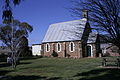
* Macarthur Street: [[Catholic Church of Christ the King]]<ref name=nswshr-1696>{{cite NSW SHR|5054618|Catholic Church of Christ the King|hr=01696|fn=H03/00188| |
* Macarthur Street: [[Catholic Church of Christ the King]]<ref name=nswshr-1696>{{cite NSW SHR|5054618|Catholic Church of Christ the King|hr=01696|fn=H03/00188|access-date=18 May 2018}}</ref> |
||
==Taralga today== |
==Taralga today== |
||
[[File:winterrainsnow 020.jpg|thumb|Winter in Taralga]] |
[[File:winterrainsnow 020.jpg|thumb|Winter in Taralga]] |
||
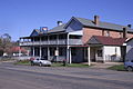
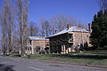
While the population of Taralga declined after the gold rush period, the character of the town did not. Today there are many historically significant buildings to be observed throughout the town. Small vineyards are located around the town. There are two heritage listed hotels, and a sports club with lawn bowling greens and tennis courts. There is a 9-hole golf course with sand greens. The town also hosts the annual "Australia Day Rodeo" and the Taralga Tigers Rugby Club always attracts big crowds during the Winter months and in the summer touch football is played. |
While the population of Taralga declined after the gold rush period, the character of the town did not. Today there are many historically significant buildings to be observed throughout the town. Small vineyards are located around the town. There are two heritage listed hotels, and a sports club with lawn bowling greens and tennis courts. There is a 9-hole golf course with sand greens. The town also hosts the annual "Australia Day Rodeo" and the Taralga Tigers Rugby Club always attracts big crowds during the Winter months and in the summer touch football is played. |
||
| Line 70: | Line 81: | ||
As of 6 February 2015, 30 turbines have been erected on site, and all are turning while in their commissioning phase. The end of construction is expected to happen around June, with the Operational period to follow soon thereafter, once AEMO testing is completed. |
As of 6 February 2015, 30 turbines have been erected on site, and all are turning while in their commissioning phase. The end of construction is expected to happen around June, with the Operational period to follow soon thereafter, once AEMO testing is completed. |
||
The layout of the wind farm can be seen through this [https://www.google.com/maps/d/edit?mid=z-8dPkqwkOY0.kRfyZL-yH1xE link] |
The layout of the wind farm can be seen through this [https://www.google.com/maps/d/edit?mid=z-8dPkqwkOY0.kRfyZL-yH1xE link] |
||
===Taralga Wildlife Park=== |
|||
There is a small wildlife park in Taralga that is keeps a number of native and domestic species including bare-nosed wombats, eastern grey kangaroos, hill wallaroos, red-necked wallabies, dingoes, dromedary camel, llama (including hybrid llama-guanaco), alpacas, donkey, miniature horses, fallow deer, blackbuck, eastern bearded dragon, blotched blue-tongued lizards, shingleback lizards, spiny-tailed skinks, wedge-tailed eagle, tawny frogmouth, laughing kookaburra, channel-billed cuckoos, blue-and yellow macaw, cockatoos (sulphur-crest, pink, yellow-tailed black, red-tailed black & gang-gang), parrots, black swans, geese, ducks, royal spoonbill, glossy ibis, helmeted guineafowl, pheasants, turkeys and others. |
|||
==Climate== |
==Climate== |
||
Taralga has |
Taralga has a temperate [[oceanic climate]] (''Cfb'') due to its high elevation. Temperatures are generally mild to warm in summer, whereas winters are cool to cold during days, with frequent frosts by nightfall. Precipitation is relatively frequent year-round, peaking in June. There are many occurrences of [[Rain and snow mixed|sleet]] and snow in the cooler months, though mainly in light to moderate quantities. Summers occasionally see frost due to a high [[diurnal temperature variation|diurnal range]] coupled with the occasional [[cold front]]. The area is prone to severe thunderstorms. |
||
The lowest maximum temperature was {{convert|1.1|C|F}} recorded in August 1962; the |
The lowest maximum temperature was {{convert|1.1|C|F}} recorded in August 1962; the highest temperature recorded was {{convert|40.5|C|F}} in January 2020. The lowest temperature was {{convert|-9.6|C|F}} in July 1982; and the highest minimum on record was {{convert|24.2|C|F}} in February 1973.<ref name="Climate statistics for Taralga">{{cite web|url=http://www.bom.gov.au/climate/averages/tables/cw_070080_All.shtml|title=Climate statistics for Taralga|publisher=[[Bureau of Meteorology]]|access-date=24 April 2020}}</ref> |
||
{{Weather box |
{{Weather box |
||
|location = Taralga |
|location = Taralga Post Office (1955–2022, rainfall to 1882); 845 m AMSL; 34.40° S, 149.82° E |
||
|collapsed = |
|collapsed = |
||
|metric first = Yes |
|metric first = Yes |
||
| Line 96: | Line 111: | ||
|year record high C = 40.5 |
|year record high C = 40.5 |
||
|Jan high C = 26.3 |
|Jan high C = 26.3 |
||
|Feb high C = |
|Feb high C = 24.9 |
||
|Mar high C = 22.5 |
|Mar high C = 22.5 |
||
|Apr high C = 18. |
|Apr high C = 18.7 |
||
|May high C = 14.5 |
|May high C = 14.5 |
||
|Jun high C = 11.2 |
|Jun high C = 11.2 |
||
|Jul high C = 10.4 |
|Jul high C = 10.4 |
||
|Aug high C = 11.9 |
|Aug high C = 11.9 |
||
|Sep high C = 15. |
|Sep high C = 15.1 |
||
|Oct high C = 18.5 |
|Oct high C = 18.5 |
||
|Nov high C = 21. |
|Nov high C = 21.5 |
||
|Dec high C = 24. |
|Dec high C = 24.5 |
||
|year high C = 18. |
|year high C = 18.3 |
||
|Jan low C = 12.1 |
|Jan low C = 12.1 |
||
|Feb low C = 12.1 |
|Feb low C = 12.1 |
||
| Line 118: | Line 133: | ||
|Sep low C = 3.1 |
|Sep low C = 3.1 |
||
|Oct low C = 5.4 |
|Oct low C = 5.4 |
||
|Nov low C = 7. |
|Nov low C = 7.8 |
||
|Dec low C = 9.9 |
|Dec low C = 9.9 |
||
|year low C = 6.1 |
|year low C = 6.1 |
||
| Line 135: | Line 150: | ||
|year record low C = -9.6 |
|year record low C = -9.6 |
||
|precipitation colour = green |
|precipitation colour = green |
||
|Jan precipitation mm = |
|Jan precipitation mm = 73.4 |
||
|Feb precipitation mm = |
|Feb precipitation mm = 71.9 |
||
|Mar precipitation mm = |
|Mar precipitation mm = 70.1 |
||
|Apr precipitation mm = 58.1 |
|Apr precipitation mm = 58.1 |
||
|May precipitation mm = |
|May precipitation mm = 59.0 |
||
|Jun precipitation mm = |
|Jun precipitation mm = 75.3 |
||
|Jul precipitation mm = 66. |
|Jul precipitation mm = 66.4 |
||
|Aug precipitation mm = |
|Aug precipitation mm = 68.0 |
||
|Sep precipitation mm = 61. |
|Sep precipitation mm = 61.3 |
||
|Oct precipitation mm = 69. |
|Oct precipitation mm = 69.9 |
||
|Nov precipitation mm = |
|Nov precipitation mm = 69.5 |
||
|Dec precipitation mm = 66. |
|Dec precipitation mm = 66.4 |
||
|year precipitation mm = |
|year precipitation mm = 804.0 |
||
|Jan precipitation days = 9. |
|Jan precipitation days = 9.3 |
||
|Feb precipitation days = 9. |
|Feb precipitation days = 9.3 |
||
|Mar precipitation days = 9. |
|Mar precipitation days = 9.4 |
||
|Apr precipitation days = 8.6 |
|Apr precipitation days = 8.6 |
||
|May precipitation days = 9. |
|May precipitation days = 9.8 |
||
|Jun precipitation days = 12.4 |
|Jun precipitation days = 12.4 |
||
|Jul precipitation days = 12.1 |
|Jul precipitation days = 12.1 |
||
|Aug precipitation days = 11. |
|Aug precipitation days = 11.4 |
||
|Sep precipitation days = 10.1 |
|Sep precipitation days = 10.1 |
||
|Oct precipitation days = 9. |
|Oct precipitation days = 9.9 |
||
|Nov precipitation days = 9. |
|Nov precipitation days = 9.2 |
||
|Dec precipitation days = 8. |
|Dec precipitation days = 8.9 |
||
|year precipitation days = |
|year precipitation days = 120.4 |
||
|source = [[Bureau of Meteorology]]<ref name="Climate statistics for Taralga">{{cite web|url=http://www.bom.gov.au/climate/averages/tables/cw_070080_All.shtml|title=Climate statistics for Taralga|publisher=[[Bureau of Meteorology]]|access-date=24 April 2020}}</ref> |
|source = [[Bureau of Meteorology]]<ref name="Climate statistics for Taralga">{{cite web|url=http://www.bom.gov.au/climate/averages/tables/cw_070080_All.shtml|title=Climate statistics for Taralga|publisher=[[Bureau of Meteorology]]|access-date=24 April 2020}}</ref> |
||
}} |
}} |
||
Latest revision as of 00:25, 31 August 2024
| Taralga New South Wales | |||||||||||||||
|---|---|---|---|---|---|---|---|---|---|---|---|---|---|---|---|
 A basalt house after snowfall | |||||||||||||||
 Taralga | |||||||||||||||
 | |||||||||||||||
| Coordinates | 34°24′20″S 149°49′07″E / 34.405465°S 149.818737°E | ||||||||||||||
| Population | 467 (2016 census)[1] | ||||||||||||||
| Postcode(s) | 2580 | ||||||||||||||
| Elevation | 845 m (2,772 ft) | ||||||||||||||
| Location | |||||||||||||||
| LGA(s) | Upper Lachlan Shire | ||||||||||||||
| County | Argyle | ||||||||||||||
| Parish | Guineacor | ||||||||||||||
| State electorate(s) | Goulburn | ||||||||||||||
| Federal division(s) | Hume | ||||||||||||||
| |||||||||||||||
| |||||||||||||||
Taralga is a small village in the Southern Tablelands of New South Wales, Australia, in Upper Lachlan Shire. It is located at the intersection of the Goulburn-Oberon Road and the Laggan-Taralga Road. It is accessible from Oberon to the north, Mittagong to the east, Goulburn to the south, and Crookwell to the west. At the 2016 census, Taralga had a population of 467.[1] Taralga is located relatively close to the famous Wombeyan Caves. The town experiences a volatile climate and is often affected by snow in the winter months.
The population of Taralga has fluctuated over time reflecting the town's fortunes. There were approximately 100 residents in 1863, growing to over 700 by the 1890s. Immediately after the depression of the 1890s, the population shrank to half this size, but recovered by the mid-1950s almost to its peak level. Today the town and its surroundings are home to around 400 people.[2]
Naming
[edit]The exact origin of the name Taralga is disputed. The two most widely supported theories are that the village was originally known as "Trial Gang" as within the early colonial boundaries of Argyle County, it was a location for the trials of convicts and bushrangers before the Crown. The second theory is that Taralga comes from the Gundungurra word for Brolga, a bird previously called the "native companion".[2][3]
A newspaper editorial in 1886 suggests the word Taralga is a corruption of 'Trialgong', an Indigenous word for 'three stony hills' (presumably in the Burra language), rather than a corruption of 'Trial gang'.[4] Also, explorer Thomas Mitchell mentioned 'Trialgong creek' in his field, note and sketchbook in 1828.[5]
History
[edit]The area around Taralga was the traditional land of the Burra Burra peoples of the Gundungurra Nation.[citation needed]. Although no major clashes with the Europeans seem to have been recorded, nor tales of collaboration with them, their last great gathering or corroboree seems to have been in the 1830s after which they are not recorded by European history. Accordingly, they would have been pushed further west to less fertile plains after the disease brought by the Europeans.
Charles Throsby passed through the Taralga area in 1819 on a journey from Cowpastures to Bathurst in search of new grazing lands. By 1824, John Macarthur's son James and his nephew Hannibal had established themselves in the Taralga region where they helped pioneer Australia's wool industry. A private village was established on land donated by James Macarthur and cleared by convicts in order to house and service members of the Macarthur family and their employees.[6] Orchard Street, now the main thoroughfare is located on the site of Macarthur's orchard. During the town's early history, Macarthur Street functioned as the main street and many examples of heritage buildings still stand here.
An 1828 census revealed a small number of residents at Taralga suggesting the village was already under way by that time, although there were probably no more than a few buildings.[7] For the first few decades of the colony of New South Wales, most of the settlers were convicts assigned to the landowners and it was they who largely cleared the land, built the huts and houses, and ran the farms. Taralga started to look like a town after the first few houses were built in the 1840s, but more rapid growth would be experienced in the 1860s in part due to the Robertson Land Acts allowing freehold title over land to settlers at favourable rates.[8]
Taralga was officially established as a town in the 1860s, with a school in 1857, and churches—Presbyterian in 1861, St. Ignatius Roman Catholic in 1864, St. Lukes Anglican in 1866 and Methodist (now the Historical Society building) in 1868. There were a number of stores, smiths and artisans' businesses and two hotels recorded in 1866. There was a large increase in population in Taralga after the 1860s, caused mainly by the gold rush bringing new migrants to the area.

In 1923, the town was visited by Premier Sir George Fuller, marking a period of renewed interest and prosperity in Taralga. During that visit, the Premier unveiled a war memorial honouring those residents who served in World War I, turned the first sod for construction of a railway link, and laid the foundation stone for the Taralga Co-Operative Dairy Company's new butter factory.[9] The 25 km (16 mi) Taralga railway line, constructed as a branch from the Crookwell line at Roslyn, opened in 1926 and closed in 1957. The line has since been lifted and little remains of the formation.[10] Electricity was first provided in the 1930s by way of a plant set up by a local, Sid Holt.[2]
Heritage listings
[edit]Taralga has a number of heritage-listed sites, including:
- Macarthur Street: Catholic Church of Christ the King[11]
Taralga today
[edit]
While the population of Taralga declined after the gold rush period, the character of the town did not. Today there are many historically significant buildings to be observed throughout the town. Small vineyards are located around the town. There are two heritage listed hotels, and a sports club with lawn bowling greens and tennis courts. There is a 9-hole golf course with sand greens. The town also hosts the annual "Australia Day Rodeo" and the Taralga Tigers Rugby Club always attracts big crowds during the Winter months and in the summer touch football is played.
The town is situated on the Goulburn-Oberon Road, designated Main Road 256 which was progressively upgraded between 2002 and 2008. Taralga is the largest settlement between the two towns and a convenient stop for travellers between Goulburn and Bathurst wishing to bypass Sydney. The town can also be accessed by rural roads from Crookwell and Marulan.
Taralga Wind Farm
[edit]On 20 February 2012, approval was granted by the New South Wales Government for work to commence on the Taralga Wind Farm. The project will see the construction of 51 wind turbines generating 106.8 Megawatts of electricity on ridges to the east of Taralga. Electricity generated by the project will be fed into the national power grid through a 38 km transmission line to Marulan Substation. The project is expected to create up to 200 local jobs during the construction phase.[12] Approval of the wind farm followed an unsuccessful challenge by the Taralga Landscape Guardians in the Land and Environment Court of New South Wales to block the project on the grounds of aesthetic and environmental impacts including noise emissions and blighting of the landscape. Chief Justice Brian Preston ruled in favour of approving the wind farm as the long-term benefit of reduced greenhouse gas emissions was in the greater public interest.[13] As of 6 February 2015, 30 turbines have been erected on site, and all are turning while in their commissioning phase. The end of construction is expected to happen around June, with the Operational period to follow soon thereafter, once AEMO testing is completed. The layout of the wind farm can be seen through this link
Taralga Wildlife Park
[edit]There is a small wildlife park in Taralga that is keeps a number of native and domestic species including bare-nosed wombats, eastern grey kangaroos, hill wallaroos, red-necked wallabies, dingoes, dromedary camel, llama (including hybrid llama-guanaco), alpacas, donkey, miniature horses, fallow deer, blackbuck, eastern bearded dragon, blotched blue-tongued lizards, shingleback lizards, spiny-tailed skinks, wedge-tailed eagle, tawny frogmouth, laughing kookaburra, channel-billed cuckoos, blue-and yellow macaw, cockatoos (sulphur-crest, pink, yellow-tailed black, red-tailed black & gang-gang), parrots, black swans, geese, ducks, royal spoonbill, glossy ibis, helmeted guineafowl, pheasants, turkeys and others.
Climate
[edit]Taralga has a temperate oceanic climate (Cfb) due to its high elevation. Temperatures are generally mild to warm in summer, whereas winters are cool to cold during days, with frequent frosts by nightfall. Precipitation is relatively frequent year-round, peaking in June. There are many occurrences of sleet and snow in the cooler months, though mainly in light to moderate quantities. Summers occasionally see frost due to a high diurnal range coupled with the occasional cold front. The area is prone to severe thunderstorms.
The lowest maximum temperature was 1.1 °C (34.0 °F) recorded in August 1962; the highest temperature recorded was 40.5 °C (104.9 °F) in January 2020. The lowest temperature was −9.6 °C (14.7 °F) in July 1982; and the highest minimum on record was 24.2 °C (75.6 °F) in February 1973.[14]
| Climate data for Taralga Post Office (1955–2022, rainfall to 1882); 845 m AMSL; 34.40° S, 149.82° E | |||||||||||||
|---|---|---|---|---|---|---|---|---|---|---|---|---|---|
| Month | Jan | Feb | Mar | Apr | May | Jun | Jul | Aug | Sep | Oct | Nov | Dec | Year |
| Record high °C (°F) | 40.5 (104.9) |
40.2 (104.4) |
36.3 (97.3) |
31.0 (87.8) |
25.7 (78.3) |
21.5 (70.7) |
19.3 (66.7) |
22.4 (72.3) |
27.5 (81.5) |
30.5 (86.9) |
38.5 (101.3) |
39.5 (103.1) |
40.5 (104.9) |
| Mean daily maximum °C (°F) | 26.3 (79.3) |
24.9 (76.8) |
22.5 (72.5) |
18.7 (65.7) |
14.5 (58.1) |
11.2 (52.2) |
10.4 (50.7) |
11.9 (53.4) |
15.1 (59.2) |
18.5 (65.3) |
21.5 (70.7) |
24.5 (76.1) |
18.3 (64.9) |
| Mean daily minimum °C (°F) | 12.1 (53.8) |
12.1 (53.8) |
9.9 (49.8) |
6.2 (43.2) |
3.2 (37.8) |
1.7 (35.1) |
0.6 (33.1) |
1.2 (34.2) |
3.1 (37.6) |
5.4 (41.7) |
7.8 (46.0) |
9.9 (49.8) |
6.1 (43.0) |
| Record low °C (°F) | 1.1 (34.0) |
1.2 (34.2) |
−1.1 (30.0) |
−4.0 (24.8) |
−6.5 (20.3) |
−7.8 (18.0) |
−9.6 (14.7) |
−7.3 (18.9) |
−6.0 (21.2) |
−4.8 (23.4) |
−2.5 (27.5) |
−0.2 (31.6) |
−9.6 (14.7) |
| Average precipitation mm (inches) | 73.4 (2.89) |
71.9 (2.83) |
70.1 (2.76) |
58.1 (2.29) |
59.0 (2.32) |
75.3 (2.96) |
66.4 (2.61) |
68.0 (2.68) |
61.3 (2.41) |
69.9 (2.75) |
69.5 (2.74) |
66.4 (2.61) |
804.0 (31.65) |
| Average precipitation days (≥ 0.2 mm) | 9.3 | 9.3 | 9.4 | 8.6 | 9.8 | 12.4 | 12.1 | 11.4 | 10.1 | 9.9 | 9.2 | 8.9 | 120.4 |
| Source: Bureau of Meteorology[14] | |||||||||||||
Gallery
[edit]-
 Taralga c1900
 -
 Taralga Church
 -
 Taralga Catholic Church
 -
 Taralga Main Street
 -
 Taralga Main Street
.jpg)


See also
[edit]References
[edit]- ^ a b Australian Bureau of Statistics (27 June 2017). "Taralga (State Suburb)". 2016 Census QuickStats. Retrieved 7 July 2017.
- ^ a b c "A Snapshot of Taralga's History". Upper Lachlan Shire Council. Retrieved 20 January 2013.
- ^ McInnes, Peter (2022). "A dance of brolgas? The meaning of Taralga" (PDF). Australia National Placename Survey. Retrieved 13 November 2023.
- ^ "TARALGA". Australian Town and Country Journal. Vol. XXXIII, no. 846. New South Wales, Australia. 27 March 1886. p. 17. Retrieved 3 September 2020 – via National Library of Australia.
- ^ Mitchell, Thomas. "Sir T. L. Mitchell's field, note & sketchbook, 1828-1830". Mitchell Library. State Library of New South Wales.
- ^ Heydon, J D. "Macarthur, James (1798 - 1867)". Australian Dictionary of Biography. Australian National University. Retrieved 21 February 2007.
- ^ "Mulwaree Shire Community Heritage Study, 2002 - 2004" (PDF). Goulburn Mulwaree Council. Archived from the original (pdf) on 19 September 2006. Retrieved 5 February 2007.
- ^ "Taralga". Towns and Villages of the Southern Tablelands NSW. Retrieved 20 January 2013.
- ^ "Taralga War Memorial". War Memorials in Australia. Retrieved 20 January 2013.
- ^ Bozier, Rolfe; et al. "Taralga Line". NSWrail.net. Retrieved 5 May 2007.
- ^ "Catholic Church of Christ the King". New South Wales State Heritage Register. Department of Planning & Environment. H01696. Retrieved 18 May 2018.
 Text is licensed by State of New South Wales (Department of Planning and Environment) under CC-BY 4.0 licence.
- ^ "Taralga Wind Farm". Renewable Energy Systems Ltd. Retrieved 20 January 2013.
- ^ Peel, Jacqueline. "Taralga Landscape Guardians case (2007)". University of Melbourne. Retrieved 20 January 2013.
- ^ a b "Climate statistics for Taralga". Bureau of Meteorology. Retrieved 24 April 2020.
External links
[edit]![]() Media related to Taralga, New South Wales at Wikimedia Commons
Media related to Taralga, New South Wales at Wikimedia Commons
| Towns | |
|---|---|
| Localities and rural places |
|
Main Article: Local government areas of New South Wales | |